By now, you have probably heard a lot of talk about the I-26 connector project. And, for those of you who haven’t, don’t worry because we’re about to dish you the 411 on the upcoming NCDOT plan. The I-26 Connector Project (or Project I-2513) is a $950 million project that involves upgrading approximately seven miles between I-26, I-240, and U.S. 19/23/70 connecting them together.

Current I-26 layout. | Photo courtesy of Asheville Design Center
The Connector Project was first proposed in 1989. There was originally a significant amount of concern from Asheville citizens because this expansion would impact many residents + businesses living within the project’s path.
Then in 2000, the community (with MountainTrue co-chairing the Community Coordinating Committee) started organizing to oppose the plan + propose goals they felt the final project should achieve. This included separation of local and interstate traffic, matching the project to the character of the community, and minimizing business + residential impact.
In 2007, the design called Alternative 4B was completed and received funding from the City and Buncombe County. And in the past decade, many improvements have been made to this plan to secure community + state consensus.
Seven miles of busy roadway will be altered + under construction for the next five to seven years as this project goes underway, displacing approximately 36 businesses, 114 homes + two nonprofits.
Keep reading to learn the complete history of Alternative 4B and the I-26 Connector Project, what parts of town will be affected, an estimated timeline + draft changes.
Bonus: The designers want to hear from community members. They’ve been holding community meetings + asking for written comments. We’re making it easy by collecting comments from our readers on the project.

Alternative 4B plan. | Photo courtesy of Asheville Design Center
In the past 11 years, minor improvements + changes have been made to the plan. This included creating a coalition of representatives in 2009 from the Asheville neighborhoods that’d be impacted by the new highway (reps from West AVL, Burton St., WECAN, Emma + Montford), forming the I-26 ConnectUS Project. In 2013, a Working Group made up of elected City + County officials as well as a representative from the business community and a representative of the ConnectUs Project worked together to reach consensus on several issues the NCDOT should analyze.
Two years later, the NCDOT issued an update for their Draft EIS (Environmental Impact Statement) to button up any final concerns. In 2016 the NCDOT selected Alternative 4B as the preferred alternative for the project. And last year, it was agreed upon that the section of highway in West Asheville needed to be six lanes rather than eight.
So, what sections of what highways will be affected?
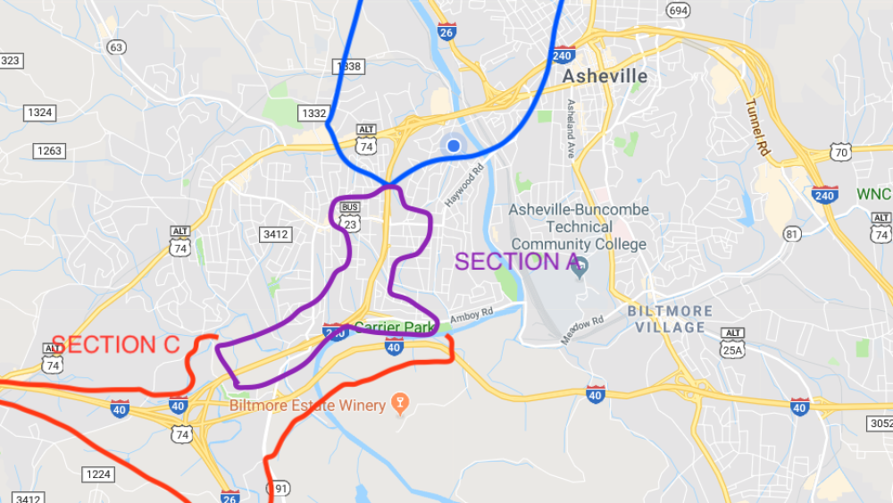
The I-26 Connector Project involves three sections:
- Section A: Upgrading I-240 (including the interchanges at Brevard, Amboy and Haywood Roads) from the I-26/I-240 interchange with I-40 to the I-240 interchange with Patton Ave.
- Section B: Building the interstate in a new location from the Patton Ave. interchange north across the French Broad River, which merges into U.S. 19/23/70 south of Broadway.
- Section C: Improving the I-40 interchanges with Smokey Park Highway, I-26/I-240, and Brevard Rd.
Why the change?
- A better means of transportation is needed to connect I-26 south of Asheville with U.S. 19/23/70 north of Asheville.
- The existing connector contains sharply curved, single-lane ramps. Current traffic using this interchange is restricted to one lane in each direction, causing backups onto I-240 at its most congested section.
- Several sections of I-240 experience traffic delays and traffic backups. Traffic congestion + delays will continue to worsen in the future as the population increases.
- The existing section of I-240 west of Asheville and the I-26/I-40/I-240 interchange do not meet current interstate design standards + are in need of improvements.
To see a full map of these sections and hotspots that will be involved, click here.
What will change?
- State figures say 36 businesses, 114 homes and two nonprofits will be displaced by this massive highway project. Some of these are a result of the bridge on Haywood Rd that goes over I-240 being torn down + widened.
- The connector project includes improving the I-26/I-40/I-240 interchange near the WNC Farmers Market, adding two lanes to I-240 in West Asheville + building a new bridge over the French Broad River north of Bowen Bridge. This would allow people traveling in west Asheville on I-240 West to get on I-40 East without having to get off the interstate.
- Improvements will also be made on the I-40/Smoky Park Highway interchange by adding an exit ramp to carry traffic from westbound I-40 to eastbound U.S. 19-23, making it easier for commuters from Candler. Drivers heading westbound on I-40 going towards Enka-Candler + Biltmore Lake will still use the existing off-ramp at exit 44, but will spend less time at the bottom because the new pattern will eliminate the need to turn left on US 19-23.
- Walking + Biking paths are planned along certain parts of I-240, Patton Ave. + Riverside Dr. At least four significant sections of these roads will get new paths.
- Thousands of motorists will see a new interchange just west of Montford on current U.S. 19-23.
- Getting off onto Amboy Road in West Asheville or driving from westbound I-240 to eastbound I-40 will be easier.
- Some property along Patton just east of Bowen Bridge could become available for redevelopment.
- The connector project will likely encourage residential growth in southern Buncombe + northern Henderson Counties because commuting into Asheville will be easier from those areas. Current congestion on I-26 deters many people who work in Asheville from living south of the city. This connecter will likely remove that deterrent.
What’s the timeline for this project?
The final Environmental Impact Statement will be submitted for approval in early 2019, and the record of decision will be submitted for approval in summer of 2019. Property acquisition + some construction will begin in 2020. It will likely take at least 5-7 years or more for the project to be completed.
How can the community get involved?
NCDOT is accepting input from the community, but there is still significant concern from the many citizens of Asheville. Asheville on Bikes has compiled a list of recommendations to make this inevitable project have the most positive impacts as possible on the community. These recommendations are suggested in order to assure safety + accessibility for bikers and pedestrians.
On December 4, the NCDOT held a public forum where people could speak their minds + ask questions about the upcoming project. Hundreds of people attended.
DOT plans to use the public forums + comments it receives through Jan. 4 to draw up a final EIS during the first half of 2019.
What do you think of the I-26 connector project? Share your comments with us here + we’ll share with our readers and the NCDOT so you don’t have to.


