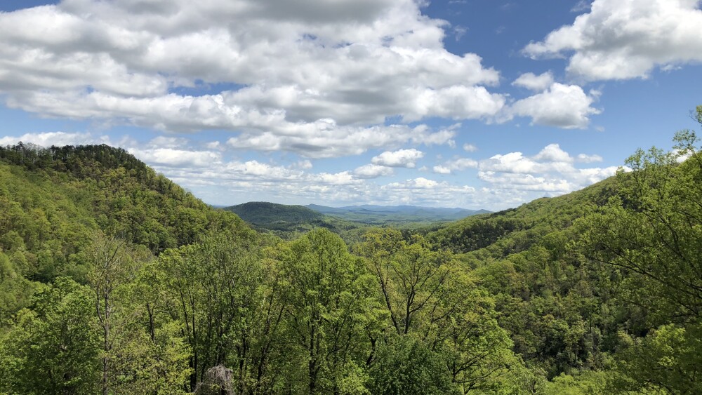
From quick and easy loops around town to drives that take you to fantastic lakes and mountains, our city has so many options to hit the trail. So lace up your hiking boots, because we’ve compiled a hiking guide for the Asheville area with 20+ routes and trails to help you plan your next adventure and experience breathtaking views.
Note: Many of our beloved trails were hit especially hard by Hurricane Helene and are still on the road to recovery. We recommend checking park websites before visiting for further info, current trail conditions, and safest practices for the area.
When you’re hiking, it’s important to take the “leave no trace” mantra to heart. Stick to the trails, always take your trash, and keep nature beautiful and clean for all visitors.
Key: Easy = 🥾 | Moderate = 🥾🥾 | Hard = 🥾🥾🥾
Close to town
Bearwallow Mountain, N35.4607, W-82.3681
- Difficulty: 🥾🥾
- Length: 2.1 mile loop
- Wheelchair accessible: No
- Pet-friendly: Yes, on leash
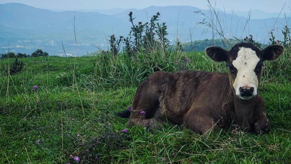
This trail slopes gently uphill, eventually leading you to a gorgeous, pastoral bald with plenty of space to roam and picnic. Very often, you’ll see cows roaming the bald.

Find some bovine companions atop Bearwallow Mountain.
Photo by @nativegvlgirl
Strawberry Gap Trail, N35.4877 -W82.3557
- Difficulty: 🥾🥾
- Length: 5-mile out-and-back
- Wheelchair accessible: No
- Pet-friendly: No
Hike through Blue Ridge Pastures to panoramic views of the Blue Ridge Mountains at the summit, and connect to nearby Trombatore Trail.
Beaver Lake Perimeter Loop Trail, 1056 Merrimon Ave., Asheville
- Difficulty: 🥾
- Length: 1.9-mile loop
- Wheelchair accessible: Gravel surface likely navigable by wheelchair, but some rocks and roots
- Pet-friendly: Permit needed for walking dogs
This mostly flat trail has sections of gravel, paved road, and dirt. Plus, the trail connects you to the Beaver Lake Bird Sanctuary — join Blue Ridge Audubon for a bird outing at the sanctuary on the first Saturday of each month.
Rattlesnake Lodge, 667 State Rd. 2109, Weaverville
- Difficulty: 🥾🥾
- Length: 3.7-mile loop
- Wheelchair accessible: No
- Pet-friendly: Yes, on leash
You’ll get a beautiful overlook view with the bonus of historical artifacts. After a good number of switchbacks and a few rocky outcrops, you’ll encounter the former site of the Rattlesnake Lodge, which was built in 1904 and gets its name from the now-defunct living room that was covered in rattlesnake skins. Note: This trail is temporarily closed in the aftermath of Helene.
Hard Times Loop Trail, 375 Wesley Branch Rd., Asheville
- Difficulty: 🥾🥾
- Length: 6.4-mile loop
- Wheelchair accessible: No
- Pet-friendly: Yes, on leash
This lovely loop is part of the trail network that traverses Bent Creek Experimental Forest and the NC Arboretum. It’s open year-round and has a moderate grade, with the exception of a steep incline about halfway through the hike.
Richmond Hill Park, 300 Richmond Hill Dr., Asheville
- Difficulty: 🥾
- Length: Various mileage
- Wheelchair accessible: No
- Pet-friendly: Yes, on leash
This city-owned park peers above the French Broad River with a surprising number of wooded trails (plus, specific zones for mountain bikers and frisbee golfers) that weave throughout the forested area. Be warned: It can be easy to get turned around here, but there’s usually plenty of friendly folks willing to point you in the right direction. Note: This trail is temporarily closed as the city is working on construction to expand surrounding trails.
French Broad River Greenway, Asheville
- Difficulty: 🥾
- Length: 3.5-miles
- Wheelchair accessible: Yes
- Pet-friendly: Yes, on leash
The greenway links Hominy Creek River Park, Carrier Park, and French Broad River Park with an asphalt trail that winds along the river. Park at any of the three parks then start on a simple, beautiful jaunt. Note: The section that runs through French Broad River Park is currently closed. See where the trail is open.
Pine Tree Loop, Bent Creek Experimental Forest
- Difficulty: 🥾
- Length: 3.2-mile loop
- Wheelchair accessible: No
- Pet-friendly: Yes, on leash
This relaxing route is a great spot for newer hikers to explore — there’s plenty of shade and minimal elevation gain. Trails are mixed-use so you can also come out here for a run or bike ride.
Asheville Botanical Gardens, 151 WT Weaver Blvd., Asheville
- Difficulty: 🥾
- Length: 0.5-mile loop
- Wheelchair accessible: Portions, hard-packed gravel with some small hills
- Pet-friendly: No
Located on UNC Asheville’s campus, this short trail provides beautiful scenery for a leisurely stroll. Plus, the gift shop is open daily from 10 a.m. to 4 p.m.
Blue Ridge Parkway and Pisgah National Forest
Catawba Falls Trail, 3074 Catawba River Rd., Old Fort
- Difficulty: 🥾🥾
- Length: 3.5-mile loop
- Wheelchair accessible: No
- Pet-friendly: Yes, on leash
This popular trail has reopened since Helene, however the upper viewing platform and Wildflower Trail remain closed for additional repairs. Visitors are encouraged to exercise caution while hiking and pay close attention to signage. Pro tip: While this trail is dog-friendly, some of the observation towers are made of metal grate materials that can be harsh on your pup’s paws.
Looking Glass Rock Trailhead, N35.290937, W82.776548
- Difficulty: 🥾🥾🥾
- Length: 6.1-mile out-and-back
- Wheelchair accessible: No
- Pet-friendly: Can be dangerous for pets
One of the most popular hikes in Pisgah, the summit of this hike offers panoramic views atop a large smooth rock that gets its name from the way it reflects ice in the winter. On the way up, you’ll encounter several springs and plenty of rhododendron and mountain laurel.
Crabtree Falls Trail, Blue Ridge Parkway Milepost 339.5
- Difficulty: 🥾🥾
- Length: 2.6-mile loop
- Wheelchair accessible: No
- Pet-friendly: Yes, on leash
This popular trail guides you to a stunning 70-foot waterfall. There’s quite a bit of uphill hiking, so it may be difficult for less experienced hikers.
Frying Pan Mountain Lookout Tower, Blue Ridge Parkway Milepost 409.6
- Difficulty: 🥾🥾
- Length: 1.5-mile out-and-back
- Wheelchair accessible: No
- Pet-friendly: Yes, on leash
The historical tower was constructed in the 1940s so that the US Forest Service could watch for fires. You can climb up the 70-foot tower for gorgeous views. Scared of heights? Don’t worry, it’s still scenic even if you don’t make the climb.
Moore Cove Falls Trail, US-276, Pisgah National Forest
- Difficulty: 🥾
- Length: 1.2-mile out-and-back
- Wheelchair accessible: No
- Pet-friendly: Yes, on leash
This easy route wanders by moss-covered outcroppings, around creeks and streams (so watch out for occasional mud), and under forest shade. The trail ends at the beautiful Moore Cove Falls, which spills over a ~50-ft rock overhang.
Pink Beds Loop, US-276, Pisgah National Forest
- Difficulty: 🥾
- Length: 5.1-mile loop
- Wheelchair accessible: No
- Pet-friendly: Yes, on leash
Sequestered in the historic Cradle of Forestry, this trail is not as pink as it name implies — but it’s a lovely place to observe wildflowers, babbling brooks, and towering pine trees. There are also several boardwalks throughout the trail that are ideal for observing bugs and other water critters.
Graveyard Fields, Blue Ridge Parkway Milepost 418.8
- Difficulty: 🥾
- Length: 3-mile loop
- Wheelchair accessible: No
- Pet-friendly: Yes, on leash
We recommend getting here early as the parking lot fills up quickly. This historic trail moves through an old fire site and several waterfalls.
Black Balsam Knob, Blue Ridge Parkway Milepost 420.2
- Difficulty: 🥾🥾
- Length: 1.4-mile out-and-back
- Wheelchair accessible: No
- Pet-friendly: Yes, on leash
This expansive bald has some of the best views in Pisgah — oftentimes, soaring above the misty Blue Ridge clouds. To get there, trek through a grove of balsams and up a rock outcrop. You’ll want to bring a jacket as it gets very windy up there.

Craggy Gardens is known for its twisty rhododenrons.
Photo by @jared_kay
Craggy Gardens, Blue Ridge Parkway Milepost 364
- Difficulty: 🥾
- Length: 1.9-mile out-and-back
- Wheelchair accessible: No
- Pet-friendly: Yes, on leash
Rhododendrons famously decorate the landscape of this iconic Asheville trail in early June — but the panoramic views of Pisgah are sublime all year long (just make sure the Blue Ridge Parkway is open before heading out). Make sure you stay on the trail and within the rock wall at the summit to avoid damaging the local flora. Note: This section of the Blue Ridge Parkway is temporarily closed.
Mt. Pisgah, Blue Ridge Parkway Milepost 407.6
- Difficulty: 🥾🥾
- Length: 4.5-mile out-and-back
- Wheelchair accessible: No
- Pet-friendly: Yes, on leash
This steep, technical trail climbs through tunnels of rhododendrons and some muddy patches to offer a rewarding summit. The hike finishes at an observation deck and transmission tower, with sweeping views of Pisgah National Forest.
Laurel River Trail, N35.912774, W82.756868
- Difficulty: 🥾
- Length: 7-mile out-and-back
- Wheelchair accessible: No
- Pet-friendly: Yes, on leash
This nice and easy hike follows the Big Laurel River and offers the perfect route for birding and trail running. Go as far as you want, but the first mile is perfect for families with small children.

Snowy sunrise over Max Patch can’t be beaten.
Photo by @jared_kay
Appalachian Trail
Max Patch Loop, Max Patch Rd., Hot Springs
- Difficulty: 🥾
- Length: 1.5-mile loop
- Wheelchair accessible: No
- Pet-friendly: Yes, on leash
Be warned: the drive up to the Max Patch parking lot is bumpy and twisty. But if you can manage that, you’ll be rewarded with a short, family-friendly hike that offers deeply memorable views of the mountains and plenty of space to picnic and frolic.
Lover’s Leap, 138 Silvermine Rd., Hot Springs
- Difficulty: 🥾🥾
- Length: 1.6-mile loop
- Wheelchair accessible: No
- Pet-friendly: Yes, on leash
This hike is perched alongside the French Broad River, so hikers will enjoy climbing over rocky, root-laden terrain — and offers many wonderful vantage points of the Appalachian Trail, river, and surrounding township.
Linville Gorge
Shortoff Mountain, Wolf Pit Rd., Morganton
- Difficulty: 🥾🥾🥾
- Length: 4.5-mile out-and-back
- Wheelchair accessible: No
- Pet-friendly: Yes, on leash
If you’re looking for stunning views of Linville Gorge and a challenging yet rewarding journey up there, this is a dream hike. Quartz crystal glistens along the trail, and you also get fun views of Lake James.
Linville Falls, Hwy. 183, Newland
- Difficulty: 🥾
- Length: 0.9-mile out-and-back
- Wheelchair accessible: No
- Pet-friendly: Yes, on leash
If you’d rather experience Linville Gorge from the perspective of the river that cuts through it, this hike offer the perfect vantage, with several waterfalls sprinkled throughout the trail. It’s best to visit April through November as it gets rather icy in the winter months.
Get the right gear
Get the most out of your trip with comfortable, handy, and helpful hiking gear:
- For the best footwear, check out Nordstrom Rack’s sneaker edit for hiking.
- If your trail demands a proper hiking boot, we like Columbia’s collection on Amazon.
- For apparel that’s both flattering and functional, we turn to small business Aesthetic Built. We love the oversized scuba hoodies for women and the muscle scallop tees for men.
- Travel light (but still have room for snacks) with lululemon’s Everywhere Belt Bag.
- Get a good bulk deal on Perfect Bars, Clif Bars, or Kind Bars at a warehouse store like Sam’s Club.
- Don’t forget to bring a compact, portable phone charger (you’ll thank us later).
- We like this Teton hiking backpack.
- We like this lightweight water bottle.
- Psst — to be ultra-prepared, here are the 10 items you should never enter a national park without, according to the National Park Service.


